STORMWATER MANAGEMENT
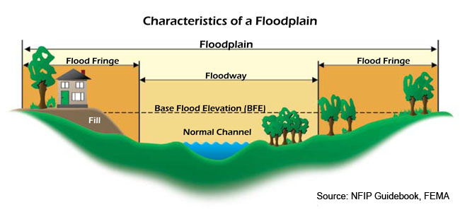
The Adopt A Drain program allows Champaign residents to help protect the environment, manage stormwater, and reduce flooding of City streets. You can help by committing to keep storm drains and the surrounding area clear of leaves and debris. Individuals, families, youth organizations, businesses, fraternities, sororities, schools…anyone over the age of 18 can sign up to help! Adopting a drain is fast and easy! Visit our interactive map, enter your email address, review and accept the Waiver of Liability, then enter your name. If you are signing up as a group, you can even create your own special team name. That’s it! You are signed up! Keep an eye out for an email with a login link and a list of the Adopt A Drain program guidelines. Now comes the fun part! Click on the login link (in your email) to access an interactive map displaying adoptable drains. Claim a drain to adopt (or two…three) and name it! Note: the City of Champaign reserves the right to reject inappropriate names. See our Frequently Asked Questions (FAQs) for more information. For information on the potential effects of climate change on stormwater, visit the following websites: US Environmental Protection Agency National Oceanic & Atmospheric Administration These rules set the basic standards for managing soil erosion that happens from land activities in the City, in areas outside the city limits for subdivision projects, and in places covered by annexation agreements, unless other agreements say otherwise. City of Champaign Municipal Code: Article V. Erosion And Sediment Control Regulations A floodplain is an area of land adjacent to a stream or river that stretches from the banks of its channel to the base of the enclosing valley walls and experiences flooding during periods of high discharge. It includes the floodway, which consists of the stream channel and adjacent areas that actively carry flood flows downstream, and the flood fringe, which are areas inundated by the flood, but which do not experience a strong current. In other words, a floodplain is an area near a river or stream which floods when the water level reaches flood stage. If you would like to find additional information on flooding risks, insurance, preparation and recovery, visit: www.floodsmart.gov. The City of Champaign participates in the National Flood Insurance Program (NFIP) and has adopted flood hazard area protection standards. As a public service, the Champaign Public Works Department Engineering Division will provide the following information upon request: Basic flood map information: Additional flood map information including floodways and regulatory requirements for development in a floodway. To request flood map information, contact Pete Vanderkloot in Public Works Engineering Division with the property’s address. He can be reached by phone: 217-403-4700, e-mail: [email protected], or you can visit the City of Champaign Public Works Department at 702 Edgebrook Drive. Sump pumps are pumps used to keep buildings dry below the ground level. Sump pumps pick up groundwater inflow or ground surface runoff and may NOT be discharged into the sanitary sewer system. Examples of building facilities connected to the sanitary sewer system are toilets, sinks, and floor drains. Sump pump discharges in the City of Champaign shall meet the requirements as set forth in the City of Champaign Codes and Ordinances Section 29. The City of Champaign has a voluntary financial assistance program for single or multifamily residential, commercial, and industrial properties within the City of Champaign built prior to 1994. The cost share is 75 percent of the system installation, up to a maximum cost share of $5,250. The City cost share will be based upon the lowest of at least two cost estimates. NPDES Phase II Permit for Stormwater Discharges from Municipal Separate Storm Sewer Systems This report and attachments detail the efforts the City of Champaign has undertaken to comply with the stormwater program outlined in the Notice of Intent for the permit period of March 31, 2021 through March 31, 2022. The report describes the status of the BMP activities, summarizes the supporting data collected, summarizes the activities proposed during the next permit year, identifies obligations required by the City of Champaign under another agency’s ILR-40 permit, and lists City of Champaign construction projects that required stormwater pollution permits. Reports from previous years: 2020 – 2021 NPDES Phase II Permit for Stormwater Discharge (IEPA) 2021 – 2022 NPDES Phase II Permit for Stormwater Discharge (IEPA) 2022 – 2023 NPDES Phase II Permit for Stormwater Discharge (IEPA) 2023 – 2024 NPDES Phase II Permit for Stormwater Discharge (IEPA) 2024 – 2025 NPDES Phase II Permit for Stormwater Discharge (IEPA) Because Champaign County is a very flat place, controlling stormwater runoff is critical to prevent flooding. Stormwater regulations are contained within Chapter 29.5 of the City Code. The City of Champaign is a member of the Champaign-Urbana Solid Waste Disposal System (CUSWDS). The annual report can be accessed below.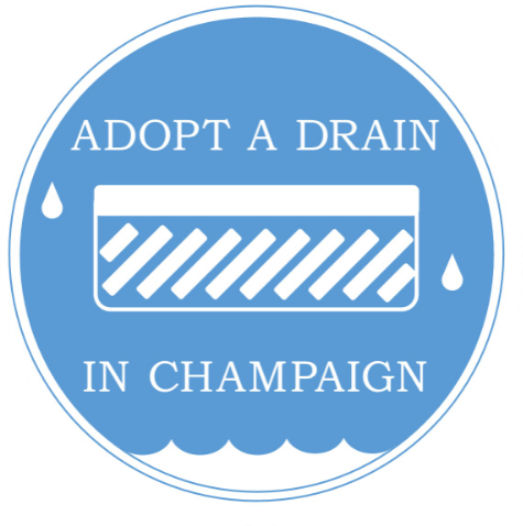
Adopt A Drain
Who Should Adopt A Drain?
Getting Started:
Caring for Your Drain:
Additional Information
Climate Change
Erosion Control Regulations
Erosion Control Standards and Permits
Erosion Control Standards:
Erosion Control Permits:
Floodplain Information
National Flood Insurance Program
Sump Pumps
Sump Pump Cost-Share Program
NPDES Phase II Permit for Stormwater Discharges (IEPA)
ACTIVE PROJECTS UNDER CONSTRUCTION
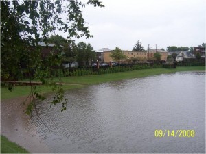
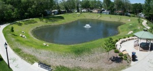
Boneyard Creek North Branch Improvement Project The Boneyard Creek North Branch Improvement Project can be divided into four geographic sections that include creek reconstruction with an adjacent lighted trail, new culverts for street crossings, detention basins, seating areas, stone column trail markers, landscaping, boulders, bioswales. Once implemented, the project will contain the 100-year flood within the creek channel and adjacent greenbelt and will improve the Washington Street viaduct to a 50-year level of protection. The project includes coordination with the City’s Bristol Place Redevelopment Project, which is within the project limits. The preliminary design is substantially complete, as documented in the draft Boneyard Creek North Branch Improvement Project Program Development Report. After final design and property acquisition is complete, the project could be constructed in up to four construction contracts sequentially from downstream (University Avenue), upstream to Neil Street. Boneyard Creek – University Avenue to Washington Street (Phase A). The downstream section of the project starts with a mid-block pedestrian crossing across University Avenue, just east of the Boneyard Creek Second Street Basin University Avenue rain garden. Park and Hill Street pedestrian crossings will also be mid-block; the crossing at Church Street will be at its intersection with Second Street. The culvert under University Avenue will be replaced, as will culverts under the alley north of University Avenue, Park Street, Church Street, and Hill Street. A new pump station for the Washington Street viaduct will be constructed with underground storage (1 acre-foot). The creek is proposed to be “daylighted” where it is currently in a culvert between University Avenue and the alley north of University Avenue. The creek will be reconstructed the remainder of its length to Washington Street with a lighted multipurpose trail the entire length of the improvement. Additional project improvements include seating areas, stone column trail markers, landscaping, boulders, and bioswales. Boneyard Creek – Washington Street to Norfolk Southern Railroad (Phase B). The second section of the project extends from Washington Street north to the Norfolk Southern Railroad tracks with additional work done west of the Boneyard Creek. The reconstructed Boneyard Creek and the associated lighted trail crosses Washington Street with a mid-block pedestrian crossing between First and Second Streets. The trail extends north to a proposed pedestrian crossing across the Norfolk Southern Railroad track at the alley west of Ash Street. The Washington Street Detention Basin (12 acre-feet) will be constructed west of the trail between Washington Street and the railroad tracks along with seating areas, stone column trail markers, landscaping, boulders, bioswales, and play equipment along the trail. This section includes a new culvert under Washington Street, renovation of the Washington Street viaduct with the addition of retaining wall and sidewalk on the south side and aesthetic improvements. Construction of the Columbia Avenue Detention Basin (8 acre-feet) is proposed at the east end of Columbia Avenue with an alternate location possible by increasing the size of the Washington Street Detention Basin. The final location will be determined in final design after additional stakeholder input. Combining the Columbia Avenue Detention Basin with the Washington Street Detention Basin would require the construction of a replacement culvert under the Canadian National railroad tracks. Boneyard Creek – Norfolk Southern Railroad to Bradley Avenue (Phase C). This section of the project expands the Oak-Ash Detention Basin by 20-acre-feet and enhances the basin with the lighted trail, a secondary trail on a boardwalk, seating areas, stone column trail markers, landscaping, boulders, bioswales, and play equipment along the trail. The trail will extend north to Bradley Avenue. A classroom pavilion is proposed in the Oak-Ash basin area and a pavilion along the creek in Wesley Park. Trailhead parking is proposed near each pavilion. A new creek alignment is proposed for the north part of this section to remove the creek from its current location under Herff Jones. The new alignment would cross the Canadian National railroad tracks in a new culvert south of Bradley Avenue, keeping the creek in a culvert between Oakwood Trace and the railroad tracks. The creek would then “daylight” across Wesley Park south to the north end of the Oak-Ash Basin. The existing culvert under the Canadian National railroad tracks would be retained to convey West Fork flow. Boneyard Creek – Bradley Avenue to Neil Street (Phase D). The Boneyard Creek trail crosses Bradley Avenue with a mid-block pedestrian crossing between Market Street and the Canadian National railroad tracks. The lighted trail extends north and west across the Bristol Park redevelopment area to a proposed pedestrian crossing across Market Street at Bellefontaine Street, then northwest across Champaign Street, Walnut Street, and Hickory Street to end at Neil Street east of Edgebrook Drive. Seating areas, stone column trail markers, landscaping, boulders, and bioswales will be constructed along the trail, in particular near the north end of Walnut Street. New culverts will be constructed under Bradley Avenue and Garwood, Market, Champaign, and Walnut Streets. The proposed Bristol Place Detention Basin (8-acre-feet) is shown with two alternate locations to allow flexibility with Bristol Place redevelopment coordination: either south or north of Bradley Avenue. A pavilion and playground are proposed in the Bristol Place area. A second alternate is shown in this section near the west end of the project. The trail could be aligned along Howard Street in a straight line alignment to Neil Street or along the south side of the Howard Street properties between Walnut and Hickory Streets to minimize pedestrian traffic along the residential Howard Street. The final location will be determined in final design after additional stakeholder input. On May 5, 2015, Council authorized an engineering drainage study in the Garden Hills Watershed that examined the causes of flooding and provided alternatives to reduce the flooding. The drainage study was completed in September 2016. As part of the drainage study, multiple alternatives were examined to reduce flooding in the Garden Hills watershed including combinations of piping upgrades, open channel improvements, permeable surface options, and detention storage. The most effective alternative was a combination of piping upgrades to transport stormwater from the watershed to a new detention basin located along the north side of Hedge Road. Locating the detention along Hedge Road is a sound stormwater management approach, since Hedge Road is the lowest elevation in the watershed. Placing the detention basin at this location takes advantage of the natural stormwater funneling effect mentioned in the previous paragraph. This detention basin will hold the excess stormwater runoff from the watershed and will include design elements so that the detention basin also functions as a neighborhood amenity. Garden Hills – Phase 1 – Complete. This phase of the project involves purchasing 46 properties along Hedge Road that are necessary to construct the proposed detention basin. The purchase of one additional property along Joanne Lane would also be necessary in order to connect the storm sewer system along Joanne Lane into the proposed detention basin along Hedge Road. Relocation assistance to property owners and renters and demolition of homes was also a part of this phase. The total cost for property purchases, relocation assistance, and demolition was approximately $4.9 million. Garden Hills – Phase 2 – In Progress. This phase of the project includes the construction of the proposed detention basin along the north side of Hedge Road and reconstruction of Hedge Road from Mattis Avenue to Hedge Court. The detention basin will be sized to hold between a 40- to 50-year storm event for the watershed. Similar to the West Washington Street project, the detention basin will feature park-like amenities such as walk paths, lighting, benches, water features, native plantings, and a variety of other landscape features. Attachment H shows the site plan for the Hedge Road detention basin. Reconstruction of Hedge Road would follow a complete street concept, which includes new storm sewer piping, full concrete street reconstruction, sidewalks and street lighting. Costs are approximately $35 million for this phase. Garden Hills – Phase 2″A” – In Progress. This project outlined the plan for the streetlighting system includes installing the City’s standard 35-foot-tall LED streetlights with pedestrian LED globe lights, generally located at intersections and mid-block points throughout the Garden Hills Neighborhood. The proposed streetlighting system includes the installation of 126 of these poles along with the installation of conduit, conductors, controllers, and all other infrastructure needed for proper function of the system. This project will not install lighting along Hedge Road or Paula Drive as lighting for these locations will be included with Phase II and Phase III of the Garden Hills Drainage Improvement Projects. This project was funded with funds from the City’s American Rescue Plan Act (ARPA) allocation in the amount of approximately $4.8 million. Garden Hills – Phase 3. This phase includes the installation of large diameter trunk storm sewers that transport stormwater from the watershed to the Hedge Road detention basin. Trunk storm sewers would be installed along sections of Garden Hills Drive, Paula Drive and Cynthia Drive. The trunk storm sewer system is the primary storm sewer system for the watershed. Work on this phase would also include complete street reconstruction, sidewalks, and street lighting. Costs are approximately $5.9 million for this phase. Garden Hills – Phase 4. This phase includes the installation of smaller diameter storm sewers that would connect directly into the trunk storm sewer system or the Hedge Road detention basin. Connecting storm sewers would be installed along Summit Ridge Road, Thornton Drive, Garden Hills Drive, Williamsburg Drive, Holly Hill Drive, Summerlin Lane, Hedge Road, Anita Drive, Burnetta Street, Joanne Lane, Marigold Lane, Honeysuckle Lane, Melanie Lane, Kirk Lane, and a section of Jeanne Street. Work on this phase would also include complete street reconstruction, sidewalks, and street lighting. Costs are approximately $12 million for this phase. Garden Hills – Phase 5. The fifth and final phase of the project would be the reconstruction of the remaining streets out to the boundaries of the study area. Minor storm sewer improvements are anticipated in this phase; however, the majority of the work will be street reconstruction, sidewalk, and street light installation. Costs are approximately $12.4 million for this phase. The drainage study found that the primary causes of the flooding were undersized storm sewer pipes and a lack of an adequate emergency overland flow path to the Copper Slough receiving channel. As a result of these drainage system inadequacies, the watershed floods with approximately 20-acre-feet of stormwater during a 50-year storm event. One of the other primary findings in the study was that the Hedge Road corridor was the lowest elevation in the watershed, and therefore, highly susceptible to flooding because stormwater runoff naturally funnels towards the lower elevations.
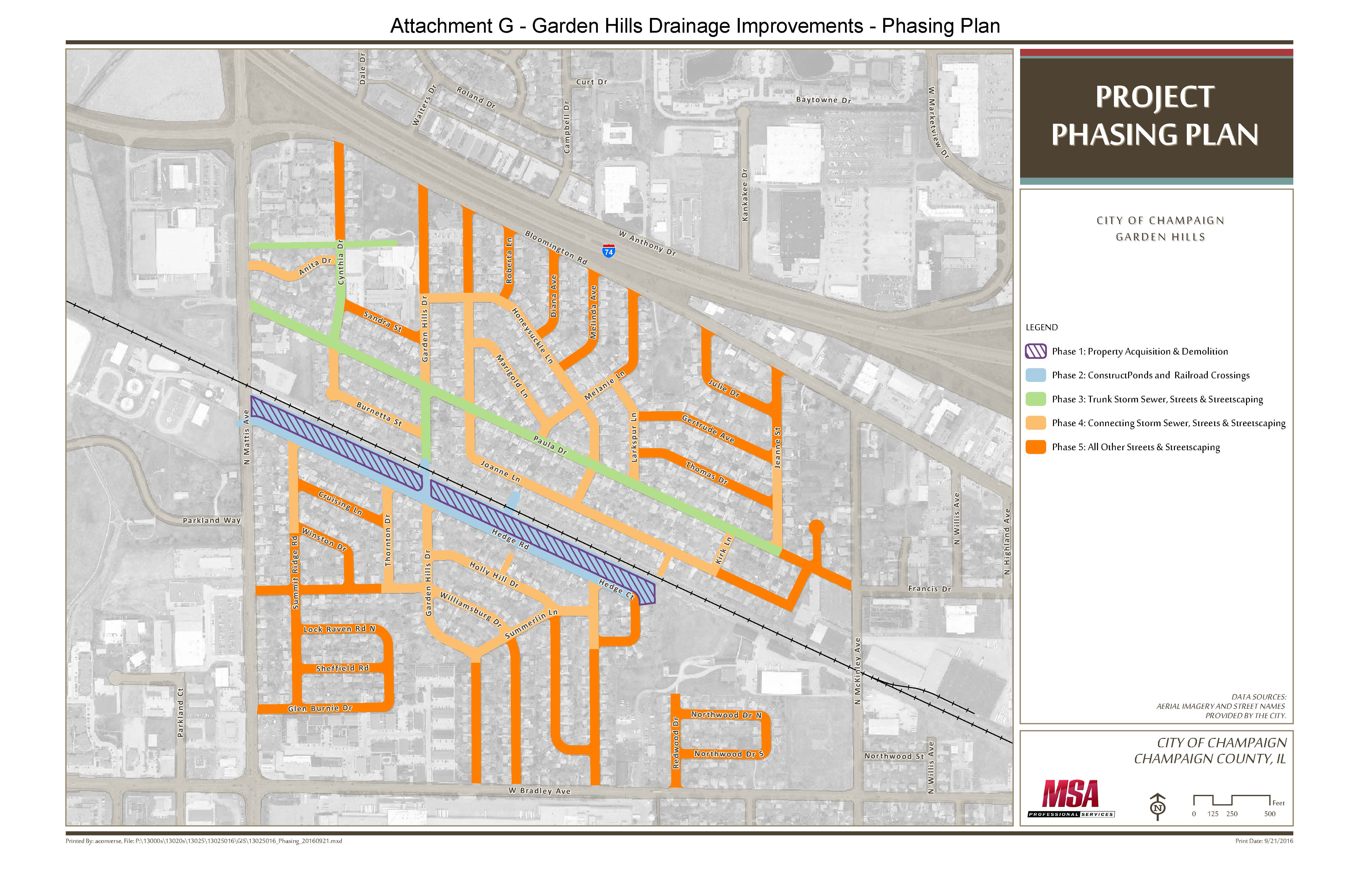 The proposed Garden Hill drainage improvement plan consists of five phases that includes a new detention basin located along Hedge Road and storm sewer pipe improvements throughout the watershed.
STORMWATER UTILITY FEE
City of Champaign Stormwater Utility Fee Information
On April 12, 2012, the City of Champaign passed an ordinance that established a stormwater utility fee. This is a fee that all Champaign properties owners will pay for City stormwater management services.
If you have questions after perusing the stormwater utility fee webpage, please contact us at 217-403-4700, and we will be happy to assist you.
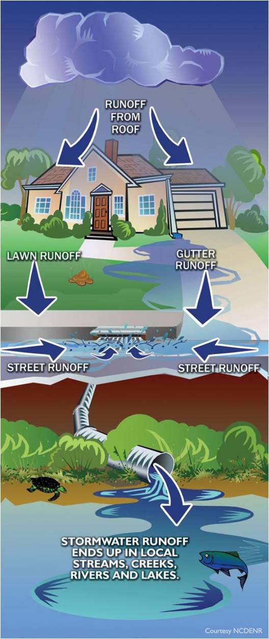
Like gas, electricity, water, and sewage, stormwater runoff can be managed as a utility and billed as a fee. The fee is based on the concept that every property in a watershed contributes stormwater runoff and should support the operation, maintenance, and rehabilitation of stormwater drainage systems in the City. The amount of support is based on the amount of stormwater runoff the property contributes to the City stormwater drainage system. The amount of stormwater runoff a property contributes is directly proportional to the amount of impervious area or hard surface that is on the property. An impervious surface is any hard surface that does not allow rain to absorb into the ground. Impervious surfaces increase stormwater runoff. Examples of impervious surfaces are roofs, parking lots, streets, sidewalks, and driveways. Champaign maintains drainage channels, detention basins and 280 miles of storm sewer pipe that cost $3 million annually for their upkeep. These maintenance expenses along with paying off bonds on past projects use up most of the stormwater fund, which leaves no funding for future drainage Capital Improvement Projects. Stormwater plans have identified $80 million of future drainage improvement projects that are needed in flood prone areas of Champaign. The recent John and East Washington drainage improvements are examples of this type of project. Revenue from the stormwater utility fee will provide funding to continue the high level of operation and maintenance needed for the upkeep of Champaign’s storm sewer system. All properties within the City that have 500 square feet or more of impervious area will pay a fee. The program is based on the concept that all property owners benefit from the City’s stormwater management programs and all properties place a demand on the City’s storm systems due to impervious surfaces creating rainfall runoff. Yes, Churches, Schools, and Non-Profit Organizations will pay a stormwater utility fee. The program is based on customers paying a fee to the City for stormwater management services to the property. Stormwater utility fees are based on the amount of impervious area on your property, which includes surfaces such as rooftops, driveways, patios, sidewalks or any other hard surfaces that do not allow stormwater to infiltrate into the ground. For Single-Family Residential Customers, the monthly billing amount is based on the amount of impervious surface area. Per CB 2024-105, the following rates are effective January 1, 2025 through December 31, 2026: How does the billing work? The City of Champaign has contracted with the Urbana and Champaign Sanitary District (UCSD) to handle billing for the stormwater utility fee. Stormwater utility fees appear as a charge on your UCSD sanitary sewer bill. Most properties receive bi-monthly bills from the UCSD. This bill will be sent on a per property basis, so if you own more than one property in the City, you will receive a bill for each property that you own, unless you have a master account set up with the UCSD that has multiple properties. As part of the Stormwater Utility Program, incentive payments or credits are available to help customers reduce their stormwater utility bill. In order to qualify for incentive payments or credits, customers must install qualifying stormwater management features on their property that help reduce stormwater runoff or improve stormwater quality. Customers have many options to choose from including rain barrels, cisterns, rain gardens, permeable pavement, and other stormwater absorbing features. The stormwater management features must meet certain requirements for reducing the amount of stormwater and/or improving stormwater quality. Customers must submit applications for incentive or credits to the City. Application forms and detailed information about the incentive and credit program are contained in the Credit and Incentive Manual. An incentive is a one-time payment for the installation of stormwater management feature while a credit is a recurring reduction off of a stormwater utility bill. Single-Family Residential Customers are eligible for incentive payments only. The only exception is that Single-Family Residential Customers who live on detention ponds that are maintained by a Homeowners or Lake Owners Association may be eligible for a 15 percent Detention Basin Maintenance Credit. The application for Detention Basin Maintenance Credit must be completed by the Homeowners or Lake Owners Association on behalf of the individual property owners. Non-Single Family Residential Customers are eligible for either incentives payments or credits off their stormwater utility bill. Non-Single Family Residential Customers include owners of commercial, retail, industrial, or any other property that is not Single Family Residential. Generally, incentive payments are $250 for each approved stormwater management feature on a property with a cap of $1,000 per property. Once the $1,000 cap is reached, no more incentives will be issued for that property. The only exception is that rain barrel purchases are eligible for $25 incentive payments for each rain barrel and there is no cap on the amount per property. Credit amounts vary from 5 percent up to 50 percent, depending on the type of credit. Credits are capped at 50 percent of the Stormwater Utility Fee for a particular property. Once the 50-percent cap is reached, no more credit will be issued for that property. You may contact the Public Works Department at 217-403-4700 to speak with a customer service representative. Generally speaking, the purpose of taxes is simply to raise revenue and there is no association or relationship between the source of revenue and the purpose to which it is applied. User fees on the other hand, are a fee for services provided, and have been commonly used to fund all or part of Public Works programs such as water, sewer, solid waste, and stormwater. The migration of stormwater program costs from taxes to fees over the last 25 years has been challenged in a number of states, and as a result the courts identify three criteria that differentiate a fee from a tax. These criteria are that there exist: 1) a regulatory nature to the fee (it must be adopted by ordinance); 2) a relationship between the fee paid and the services provided (the fee in this case pays for stormwater management related services and programs only and is rationally distributed between ratepayers); and 3) a voluntary nature to the fee (you can reduce fees by reducing use of the stormwater system or program). This last criterion includes the concept of credit programs to reduce costs. The City’s stormwater utility fee would result in more funding for stormwater capital projects. Specifically, the City’s stormwater utility fee would fund stormwater operation, maintenance, and rehabilitation expenditures. Those activities are currently funded by sales and property taxes. If those activities are funded in the future by a stormwater utility fee, then the sales and property taxes would be available for other City needs. Council has indicated these available sales and property taxes would be used for additional stormwater capital projects. Council has made no final decisions on which capital projects to fund. However, Council has indicated that three projects are top priorities, which are: Healey Street Detention Basin To date, the City has completed approximately $38.2 million of improvements on the Boneyard Creek. Projects include the Healey Street Detention Basin, channel improvements north of Green Street between Sixth and First Streets, the Scott Park channel improvements and detention, and the Second Street Reach channel improvements and detention. These improvements have eliminated all the flooding that used to occur along Green Street, through Scott Park, and along Second Street between Springfield Avenue and University Avenue. The projects also eliminated flooding of the Green Street viaduct. Due to the aesthetics that were incorporated into these projects, Scott Park and the Second Street Reach were transformed into beautiful community spaces. The existing funding also provided $5.3 million for storm sewer improvements to eliminate flooding in the Springfield Avenue, Logan Street, and Chester Street viaducts. The flooded viaducts were a frequent nuisance disrupting traffic and creating public safety concerns. Finally, existing funding has provided resources to complete drainage improvements that addressed longstanding neighborhood drainage issues in the John Street ($6.1 million) and East Washington Street watersheds ($1.8 million). In total, existing stormwater funding has provided $51.4 million for stormwater capital improvements. The City of Champaign is not alone as far as a Stormwater Utility Fee goes. Several Illinois communities have instituted a Stormwater Utility Fee including Aurora, Bloomington, Downers Grove, Highland Park, Moline, Morton, Normal, Rock Island, Rolling Meadows, and Urbana. The Stormwater Utility Fee allows the City to continue funding all of its existing stormwater services at their current levels. For a description of current services and funding, see the Existing Stormwater Activities and Expenditures. The Stormwater Utility Fee also provides additional funding for drainage capital improvements. It’s estimated the City’s Stormwater Utility Fee generates approximately $2.6M annually in additional revenue. Staff started work on the Stormwater Utility Fee in October 2009. Between 2009 and 2012, there were five Council Study Sessions on the Stormwater Utility Fee. Additionally, Council has passed four resolutions related to the Stormwater Utility Fee, plus one ordinance which established the Stormwater Utility Fee. To help with the evaluation, Council established a Stormwater Utility Fee Advisory and Technical Committee. The committees met from September 2010 through July 2011. The advisory committee was reactivated to assist staff with the completion of the Credit and Incentive Manual for the Stormwater Utility Fee. The reactivated committee met monthly in June, July, and August 2012. There were four public information meetings on the Stormwater Utility Fee, plus staff met with numerous individual and group stakeholders concerning the fee. The completed outreach activities and written public input were attached as Exhibits D and E to Council Study Session, February 28,2012, Report to Council. Preservation Pond On March 23, 2010, Council directed staff to develop an Expenditure, Revenue, and Billing Plan for a City Stormwater Utility Fee. The purpose of the plan was to provide specific information on how a Stormwater utility fee could operate in the City. Staff indicated this plan would help Council in reaching a decision on whether or not to implement a Stormwater Utility Fee for the community. For a summary of the plan, see Expenditure, Revenue, and Billing Plan. The best sources for information on the City of Champaign’s stormwater utility fee evaluation/consideration are the Reports to Council that staff prepared for the three Study Sessions that have been held on the fee. Links to these reports are listed below: Additional reports and resolutions for other Council actions are listed below. These actions established the Stormwater Utility Fee Advisory Committee, appointed members to the committee and hire AMEC Earth an Environmental, Inc. to provide technical assistance for the fee. SS 2010-022: March 23, 2010. This Study Session Report to Council provided Council with information on stormwater utility fees and obtained Council input on whether staff should proceed with the next implementation step for the stormwater utility fee: establishing a Stormwater Utility Fee Advisory Committee and developing a preliminary expenditure, revenue, and billing plan for a City of Champaign stormwater utility fee. CB 2010-127 and CB 2010-128: June 15, 2010. The purpose of these Council Bills was to authorize the following actions: CB 2010-168: August 3, 2010. This Council Bill authorized the City Manager to execute a standard professional services agreement with AMEC Earth and Environmental, Inc., Indianapolis, Indiana. AMEC will assist staff with the preparation of an Expenditure, Revenue, and Billing Plan for a City of Champaign stormwater utility fee. SS 2011-019: March 29, 2011. The purpose of this report was to review the Stormwater Utility Fee Expenditure Plans and obtain Council input on the plans. SS 2012-054: October 23, 2012. The purpose of this report was to review the Credit and Incentive Manual for the City’s stormwater utility fee and obtain Council’s input on the Manual. CB 2013-197: On November 5, 2013, Council approved and Ordinance amending Section 29-8.15.3. Stormwater utility fee and Section 29.5-6.04 Stormwater utility fee rate structure of the Champaign Municipal Code, 1985. Credit Applications: Please send all completed applications and forms to: Public Works Department For questions regarding forms and applications, please contact Leslie Mitchell at 217-722-5746. Monday, September 13, 2010 Monday, October 11, 2010 Monday, November 8, 2010 Monday, December 13, 2010 Monday, January 10, 2011 Monday, February 14, 2011 Monday, March 14, 2011 Monday, April 11, 2011 Monday, May 9, 2011 Monday, June 13, 2011 Monday, July 11, 2011 Monday, June 18, 2012 Monday, July 16, 2012 Monday, August 13, 2012 What is a stormwater utility fee?
Why is the fee needed?
Billing Questions
Do I have to pay a stormwater utility fee for my property?
Do Churches, Schools, and Non-Profit Organizations have to pay the fee?
How much is my stormwater utility fee?
Credits and Incentives Questions
How can I reduce my stormwater utility fee?
What is the difference between an Incentive and a Credit?
How much are Incentives and Credits? Are there caps on them?
Who can I speak to about my stormwater utility bill?
Why is the stormwater utility charge a fee and not a tax?
What will the revenue from the stormwater utility fee be used for?
With the existing funding, what stormwater capital improvements have been completed?
Do other communities utilize a stormwater utility fee?
What does the Stormwater Utility Fee mean to the community and the citizens of Champaign?
How much additional revenue would the City’s Stormwater Utility Fee provide?
Background
Stormwater Utility Fee Expenditure, Revenue, and Billing Plan
City Council Documents Regarding the Stormwater Utility Fee
Council Documents:
Credit and Incentive Manual
APPLICATIONS:
(Rain barrel / Rain garden reimbursement)
Other Forms
Please save this form to your computer prior to entering your data. Completed forms can be mailed to the address below or emailed with photo attachments to: [email protected].
Credit and Incentive Manual Versions:
Attention: SWUF
702 Edgebrook Drive | Champaign, IL 61820
To help with the development of the stormwater utility fee, Council established the Stormwater Utility Fee Advisory Committee (CB 2010-127).
Meeting Documents
Meeting Presentations:
For more information, please contact:
City of Champaign
Public Works Department/Engineering
702 Edgebrook Drive | Champaign, IL 61820
217-403-4700
[email protected]